Was Clover Island Once Ten Times Bigger Than Now? What ‘Shrunk’ It?
When we think of Clover Island, many vision the Clover Island Inn, the lighthouse, and walks, bike riding, and more.
According to the Port of Kennewick,<a href="https://www.portofkennewick.org/projects/clover-island/"> the original island was at one time 162 acres,</a> and was much lower than it is today.
But few realize this natural then man-altered island was once ten times bigger, and part of a series of smaller dots in the river.
First discovered by Lewis and Clark during their expedition, Clover Island was so named because early Pasco and Kennewick residents noticed the undeveloped land was covered in clover (the plant). Had nothing to do with its shape.
Lewis and Clark noted the island on October 17, 1805 from their expedition log.
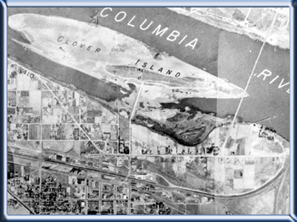
According to the Port of Kennewick, the original island was at one time 162 acres, and was much lower than it is today. There were five smaller 'dots' of islands nearby, but those went away in 1953 with the higher river levels from McNary and Ice Harbor Dams on the Columbia and Snake Rivers. Below is a shot of the island in 1953, much smaller.

The rocky shoreline next to the 'no wake' zone harbor where a lot of boats are moored year-round was the original shoreline. But then after McNary, the rocks were brought in to reinforce and build up the shoreline, and the pond area was created for boating mooring.
The Coast Guard Station was moved from further down the Columbia to Clover Island in 1962, and the distinctive lighthouse was built in 2010 as part of efforts to upgrade the facilities.
Many don't know during World War II, there was a 300 foot-long dock that went out into the river from the island, which was much larger and lower than now. Barges were built there, and a lot of water traffic. The dock is pictured below.

But after the famous floods of 1948, much of that infrastructure was damaged or destroyed. May 31st, 1948, according to Historylink.org. the second-worst flood in our region's history displaced over 1,000 residents and disturbed or destroyed much of the Kennewick and Richland shoreline. It was after this flood officials decided to build up the shorelines.

Some dredging was done west of the Blue Bridge, and the huge basalt boulders we see today were brought in.
But Clover Island saw the most renovations. The formerly 162-acre spread was raised using the dredging from the river, built up to the level it is today, and the end result was a much smaller 16-acre island. Its shape has not changed much since then.
By the way, Columbia Park Trail- Columbia Drive through Columbia Park was once THE highway from Richland to Kennewick, and it was known as Highway 410.
Now when you are on Clover Island, imagine it being ten times larger and probably at least 15 feet lower...wow!
This is how it looks today. Courtesy of the Port of Kennewick.

Speaking of history...
CHECK IT OUT: Here Are the 77 Most '70s Things About 1977
More From 870 AM KFLD